| Photos From Wyoming Tales and Trails This Page: Golden Gate Canyon, Dan Kingman, Geologic Formation of Yellowstone. |
 |
|
| Photos From Wyoming Tales and Trails This Page: Golden Gate Canyon, Dan Kingman, Geologic Formation of Yellowstone. |
|
|
|
|
About This Site |
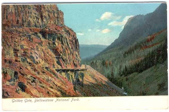
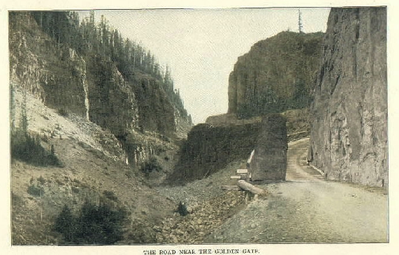
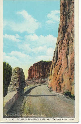
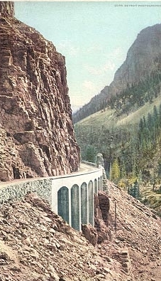
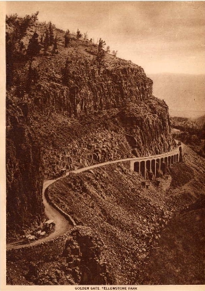
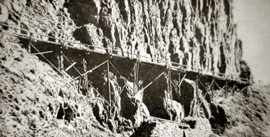 Close-up, Kingman's Trestle "The plan of development which I have submitted is given upon the supposition and in the earnest hope that it will be preserved as nearly as may be as the hand of nature left it, a source of pleasure to all who visit and a source of wealth to no one."
Later Kingman worked on flood control along the Mississippi and ultimately became the Chief Engineer for the Corps (1913-1916). By the time of his departure from Yellowstone, the first 30 miles of roads and bridges had been completed. The Grand Loop Road was subsequently completed in 1915. It remained, however, dusty and was oiled in 1926. Paving was completed in the 1940's. The rocks in the Golden Gate Canyon consist of volcanic ash, pumice and rock particles which have cooled and welded together to form a dense rock known as "ash-flow tuff" or "welded tuff." Many of the features of Yellowstone arise out of a cataclysmic volcanic eruption some 600,000 years ago. During the "Quaternary Period," 2 million to 3 million years ago, the area that is now Yellowstone drifted southwesterly over a "hot spot" beneath the Earth's crust. A hot spot is an area where molten lava is closer to the Earth's surface and as the overlying plates drift about on the planet, the overlying land or water will be subjected to volcanic activity. Today an example is seen in Hawaii. The Pacific Plate is moving northward toward the Alutians. Thus, a string of islands are formed as the plate drifts northward over the hot spot: first Kauai, then Oahu, Maui, and Hawaii the newest. In the instance of Yellowstone, earlier volcanic activity, as much as 17 million years old, associated with the hot spot has been found to the west in Idaho and Washington State. And as the plate moves westward, the hot spot in relation to Yellowstone and Wyoming will move northeastward beneath Montana in the general direction of Manatoba. Scientists are hopeful that with a thicker Earth crust to the northeast, the danger of future major eruptions will be reduced. In Yellowstone there was older volcanic activity 55 to 40 million years ago. During that time the Absaroka and Washburn Ranges were formed. However, the formation of the most prominent features of present-day Yellowstone began two million years ago. As the area drifted over the hot spot, an explosive rhyolite lava accumlated beneath what is now the Park. From cracks in the overlying rocks, lava oozed, releasing pressure on the remaining molten rock, permitting it to explosively expand. The force of the explosion was many times that of the eruption of St. Helens or that of Krakatoa in 1883. The Krakatoa explosion could be heard 3,000 miles away and formed a dust cloud 50 miles high. The size of the Yellowstone Hot Spot explosions may be illustrated by the fact that an earlier eruption in Idaho 10 million years ago, buried alive in volcanic dust, camels, rhinoceros, and deer in northeast Nebraska almost a 1000 miles away. Most traces of the explosion from 2 million years ago have disappeared, destroyed by another violent explosion 1,200,000 years ago and one only 600,000 years ago. The more recent eruption formed a caldera over 30 miles wide, much of which now forms the Lake Yellowstone basin.
In Yellowstone, the explosion was fueled by two large magma chambers filled from below. First one chamber erupted and then the other, causing almost the entire park to be buried in the tuff. Only very high ridges such as Mt. Washburn remained uncovered. With the eruption, the magma chambers collapsed leaving a crater possibly as much as 2,000 ft. deep. And yet again, some 125,000 to 200,000 years ago, another violent eruption rocked the landscape. Somewhat smaller, the eruption formed a caldera which is now the West Thumb of Lake Yellowstone. Over the next 10's of thousands of years, other smaller eruptions of lava have occurred, erasing many traces of the giant caldera. The last of these eruptions was about 60,000 years ago. Some local lava flows cooled quickly forming a natural glass, such as may be viewed at the Obsidian Cliff. The most unique of Yellowstone's features are its hot springs, geysers, and fumaroles. Although such occur elsewhere in the world including Iceland, New Zealand, and near Mammoth Lake, California, no place are there as many. These give evidence that volcanism is not yet dead in Yellowstone. Beneath the earth, the rock remains hot. Surface water perculates down through faults, there to be heated to as much as 465 deg. F. At depths where such heat is encountered, the water does not boil due to the pressure from above. As the water is heated, it rises to be replaced by cooler water from above. If the water rises unobstructed it will form a hot spring. If obstructed when the upward blockage is overcome, the pressure will be suddenly released, causing water below to explode into steam causing the eruption of a geyser. The second major feature of Yellowstone is the Grand Canyon. It, too, owes much of its formation to the effects of both the formation of the caldera described above and the hot waters perculating through the rock. As noted above, some 50 million years ago there was a period of volcanism associated with the formation of the Absaroka Range. During that period, the area was overlain with lava, ash, and material ejected by the intermittent volcanic eruptions. The nature of these eruptions is illustrated by the petrified forest in which whole trees, still standing erect, were covered. Mount Washburn is a portion of one of the Absarokan volcanoes. For a period of about 1.4 million years, an ancestral Yellowstone River flowed, slowly cutting a canyon. With the eruption of the caldera 600,000 years ago, the canyon was filled with the tuff. In the area below what is now the Lower Falls, the hot water caused a chemical change in the rhyolite causing it to be softer and more susceptible of erosion. This change also caused the colors seen in the canyon. Such change did not occur in the area of the falls, causing the rock at the falls to be harder.
Following the eruption, the river began to recarve its channel along its old route. Lava flows blocked drainage and formed a lake, which eventually emptied into the Yellowstone River, causing the canyon to be further eroded. This erosion was halted several times by the advance of glaciers. The most recent period of glaciation was approximately 25,000 to 12,000 years ago. During this period, known as the "Pinedale Glaciation," ice flowed out of the Absaroka Range southeast of the Park and into the Yellowstone Lake basin. Evidence of the glaciers may be seen in moraines which form rock debris hills where the glaciers ended. Further signs are seen in large boulders of rock not native to the area and which are strewn throughout the Park. The ice in the area of the lake basin was as much as 3,000 ft. thick. Some 90% of the present day park was covered by the ice. Although, the ice covered the canyon, it did not flow down its canyon, and, thus, did not form a glacial valley such as might be seen at Yosemite. In places the ice or the moraines blocked streams and formed lakes. When the ice dams would break, giant floods would roar down the valleys. The most spectacular example, although not in Yellowstone, was Lake Missoula. 15,000 years ago, a continental glacier blocked the Clark Fork River forming a lake 900 feet deep and extending back as much as 200 miles. Under the pressure from the water the 2,000 ft. ice dam would break. In two days a lake equivalent to Lakes Erie and Ontario combined would be drained. Five hundred cubic miles of water roared down the Columbia forming the scab lands of Washngton State and carrying rocks from Idaho to central Oregon. Not once, but multiple times the glacier advanced blocking the river and multiple times the flood scoured the land. On a smaller scale, similar effects from a smaller ice dam may be seen near Gardiner. With the end of the Pinedale glacier 12,000 years ago, the formation of the Grand Canyon of the Yellowstone resumed. Complaints are sometimes voiced as to the quantity of traffic on the Grand Loop Road in the summertime. In the winter most of the park roads are closed. Nevertheless, as indicated in the next photo, traffic problems persist. 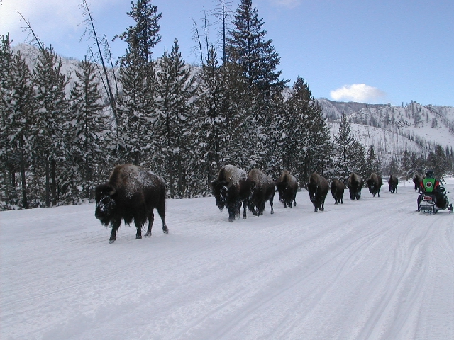
Winter, 2001, Photo by Harvey Cassidy
Next Page, Yellowstone continued. |