| From Wyoming Tales and Trails This page: Midwest, Western Interior Seaway, Oil Formation, Anticlines and Traps. |
 |
|
| From Wyoming Tales and Trails This page: Midwest, Western Interior Seaway, Oil Formation, Anticlines and Traps. |
|
|
|
|
About This Site |
|
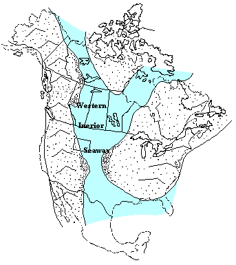
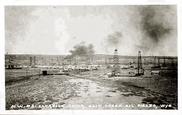 Canadian Camp, Salt Creek Oil fields, approx. 1930. The story of petroleum in what is now Wyoming, however, goes back some 220 million years. At that time there was but one continent, Pangea, which began to split, much in the same fashion that Africa is now splitting in the Rift Valley. For millions of years a portion consisting of present day North America becane to drift westward in relation to what is now Africa. The movement was driven by convection currents of the molten core of the Earth. The eastern portion of the North American Plate began to subduct beneath the western portion, thus causing the central portion to be depressed. The ocean levels were higher and the central portion of the North American Continent was considerable lower, with the result that there opened what is now known as the "Western Interior Seaway" in which a shallow sea covered the central portion of the continent and connected the Gulf of Mexico with Hudson's Bay and Arctic Ocean.
At the time, known as the "Cretaceous Period," 130 million to 67 million years ago, the Earth's climate was much warmer than at present and North America was much closer to the equator. Over millions of years alga and other plant and animal life thrived in the warm sea and as they died they drifted to the bottom of the sea. Erosion carried sand and silt into the sea, covering the organic material. Additionally, on the land, volcanoes would erupt and layers of ash would form, created a mineral found in Wyoming known as Bentonite. Bentonite processing plants are found in Worland, Casper, Glen Rock, Moorcroft, and Mills. The mineral is used in slurry for oil drilling bits and for cat litter. As climate, sea level, and other conditions changed, the layers of material would change. Some layers were primarily sand or mud, and other layers would have a greater degree of clay. Under the weight of the deposited materials, the sand would turn to sandstone, the mud to mudstone, and the clay to shale. At times when there were many shell fish, limestone would form. Thus, over the millions of years the deposits would continue to grow, layer after layer. And as the weight of the deposits grew, the Earth's crust would depress so that while the depth of the sea changed but little, the deposits grew in thickness to as much as 12,000 feet. Gradually, the level of the continent rose and the sea filled in. With the pressure from the weight of the rock above and the heat of the Earth, chemical changes took place in the organic material and it slowly became petroleum. As organic material became petroleum, the pressure of the rocks above would cause the petroleum and water to migrate through the permeable rocks, sometimes for great distances. The petroleum would tend to float on top of the water. It would continue to migrate until it would come to a layer of impermeable rock, such as shale.
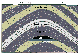
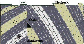
After millions of years, long after the sea had disappeared, the Rockies began to form, an event known as the "Laramide orogen." And as the Rockies arose, the rocks would bend and sometimes break. As they would bend, they might form arches, known as anticlines. As the oil migrated, it would be blocked by impermeable rock, known as "cap rock," as illustrated in the diagram to the lower left. Another cause of petroleum becoming "trapped" would be though the formation of a fault. If the rocks broke, a fault would form and impermeable rock, such as the shale, might be shifted so that it blocked a layer of the permeable sandstone, as illustrated by the diagram to the lower right. A third form of a "trap" would be a salt dome common along the Texas coast. From the ancient sea, salt would coalesce and form domes which would intrude into the permeable rock and block the migration of the petroleum. Thus, the petroleum would be trapped in pockets in the rock. Thus, a "dome" is an underground structure and is not something which is readily observable on the surface, such as the writer imagined when a small boy. As the sea level rose and fell, the seaway slowly filled in from the erosion of the surrounding land and along a coastal plain there were swamps. As the vegetation died it to was covered, formed peat, and as the peat was compressed by the weight of the material above, it slowly formed into coal. Older texts generally associate oil strictly with marine organic material. Some recent studies also indicate an association with extremely deep (6,000 - 12,000 ft. deep) coal beds. The disappearance of the seaway also resulted in the formation of gypsum.
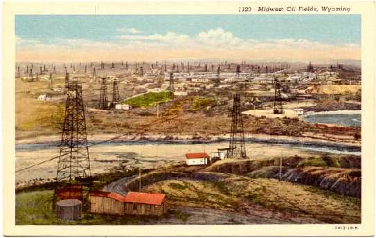
The presence of the seaway also had an additional impact on Wyoming. The width was such that the seaway separated the dinosaurs, so that entirely different species were found in what later became the American West from those found in the east. In the diagram to the right, oil has migrated in the sandstone, until it was blocked by a layer of shale which has shifted almost vertically. In the diagram, sandstone layers at the right break the surface and form "hogbacks," a formation frequently seen in Wyoming. Examples may be seen along Rte. 59 between Douglas and Gillette, a rather long and desolate road. In the diagrams, the distance below the surface of the anticlines and traps is much reduced. The traps can be as much as 14,000 feet in depth below the surface. The principal town in the Salt Creek Field is Midwest and its nearby sibling Edgerton. Originally, there were other camps and towns such as Lavoye discussed on a subsequent page and Canadian Camp pictured at the top of this page. They are all gone now. The last of the outlying camps closed in 1959.
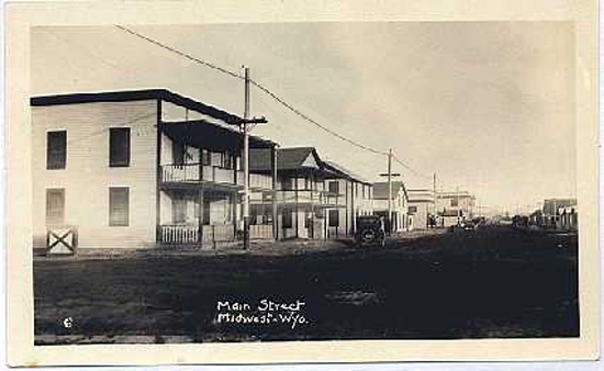
 The Town of Midwest, Approx. 1920 Midwest itself dates to about 1912 when the first one-room school was established. The first buildings, as in other boom towns and as depicted on the next page with regard to Lavoye, were tents. The first permanent buildings came several years later.
 Midwest, Wyoming, 1920's In 1959, the town ceased to be a "company town" when the residents were permitted to purchase their own homes from the oil company. Midwest as a town became an incorporated muncipality in 1978. Next Page, Midwest continued. |