|
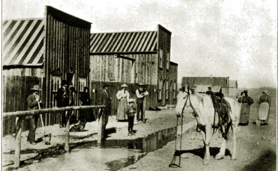
Cody, Wyoming, 1897.
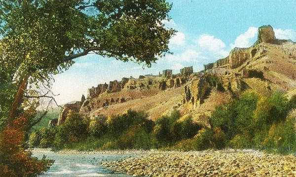
A few miles west of present-day Cody and west of Cedar and Rattlesnake Mountains, the South and North Forks of the Sinking Water River (now, by act of the
Legislature, known as the Shonshone) combine. The stream then flows northeastward past some suphurous hot springs now named
after an early settler Charles DeMaris (1827-1914), who discovered the springs in 1886 and proved up his homestead
in 1896. Early mountain men named the river from the characteristic aroma emitted by the
springs. Indeed, early hunters noted that the smell of the springs was perceptible several mies downstream.
The river ultimately unites with the Bighorn east of Lovell. The Bighorn in turn flows into the Yellowstone continuing northeast
across Montana until it combines with the Missouri in North Dakota. To the northwest of Cody arises Skull Creek a tributary of
Pat O'Hara Creek which in turn feeds into the Clark's Fork.
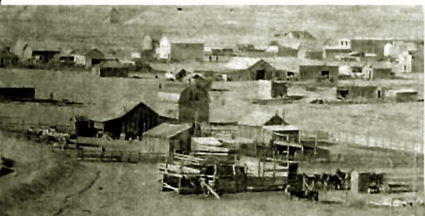
Cody, Wyoming, 1899.
Into this area in 1879 Jim Carter trailed about 3,000 head of cattle
from Oregon to form the nucleus of the Carter Ranch along the South Fork of the Stinking Water. Carter Mountain
to the south of Cody derives its name from the Carter Ranch.
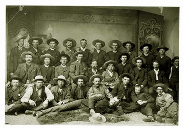
Carter Cattle Company cowboys, undated.
And to
the area of Pat O'Hara's Creek, John Chapman also trailed catte from Oregon in 1879. Chapman's ranch was located near the
present-day Two Dot Ranch. In 1880, Captain Henry Belknap's Cattle Company of Billings, Montana, trailed a herd from into the
area of the South Fork of the Stinking Water. See Larson, 2nd ed. p. 166.
Captain
Belknap (1826-1909, Harvard class of 1845). It is unclear whether the title "captain" was received as a result of military service in the Civil War (18th Infantry) or as a result
of his ownership of the ninety-nine foot twin-engined steam yacht Magnolia. He is regarded as an ealier settler of Meeteetse.
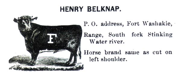
Belknap Brand and usual range, 1884.
Captain Belknap had extensive real estate and other holdings in Montana, New York, Massachusetts and Florida. His usual residence
in the summer was at Shelter Island, New York and in the winter at St. Augustine, Florida. He was a member of Yacht Clubs in both places.
In St. Augustine he combined three different houses to form a large
residence overlooking Matanzas Bay. The residence is now a bed and breakfast.
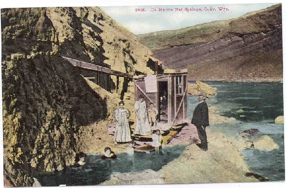
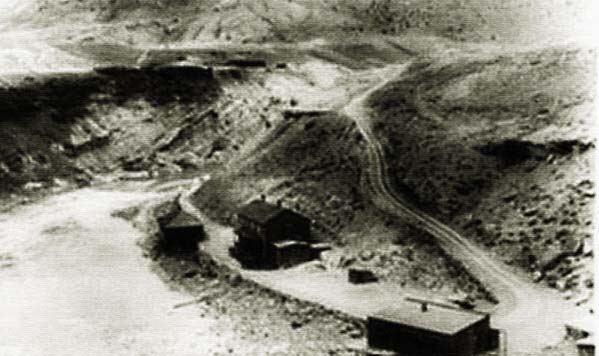
DeMaris Springs, approx. 1910
The small shed depicted in the image was in place at least by 1897 and was heated in the winter by a stove.
The water from the springs were bottled for their medicinal value by William Yager who later founded the
Cody Bottling Works.
DeMaris Springs. Photo by F. J. Hiscock.
DeMaris Springs were named after Charles DeMaris (1827-1914) who homesteaded in the
area in the late 1880's and proved up his homestead in 1894. Allegedly,
Col. Cody wanted to locate his proposed city at the Springs. There was, of
course, a problem, it was owned by DeMaris. DeMaris had to go through two different lawsuits
to maintain his title.
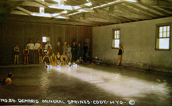
Interior DeMaris Springs Bath House, approx. 1925
As suggested above, earler the mountain men came into the area. Perhaps the earliest were
Colter and George Drouillard of the Lewis and Clerk expedition. Drouillard, referred to in the Lewis and Clark
Journals as "Drewyer" was a relative of Laramie after whom the County, City, mountain, and two rivers are named. See
Rendezvous. See also Skarsten, M. O.:
George Drouillard, Hunter and Interpreter for Lewis and Clark & Fur Trader, 1807-1810, Arthur H. Clark Co., 1964.
The naming of Hart Hountain, visible from Cody, is attributable to
Drouillard possibly from the sighting of Elk. The term hart was a common term for a red stag. Today a debate continues as to the derivation of the name. An early map from the Lewis and Clark Expedition shows it as
"Hart Mountain." More recent usage shows the mountain as "Heart Mountain." Was the name as a result of
mis-spelling by Drouillard and allegedly as a result of the summit when viewed from certain angles taking on the appearance of
a heart? Alternatively, was the name derived from numerous elk found in the area and being referred to by Droulliard by old term for a stag? Or is the use of the term
Heart" a false etomology derived from "hart." At the time of the Lewis and Clark Expedition, Elk were not commonly known in the east. It would be very easy to use the term
Hart to describe the animal. Describing the mountain as
resembling a heart seems to the writer as a stretch. Thus, it may be argued that the name of the mountain was derived from the
animal just as Elk Mountain in Carbon County and Wapiti along the Shoshone are named after the
animal. Today, the term "hart" is more commonly used in the name of
British pubs and restaurants. An albino hart was the personal device of Richard II.
Other settlers came: Pat O'Hara after whom the creek and the mountain is named; George Marquette who came in 1881 and discussed with regard to the small town of
Marquette on a later page; Charles L. Green;
Charles A. Davis and artist Arbraham Archibald "A.A." Anderson, discussed on the previous page and later mentioned with regard to the Cody Road.
Historian David J. Wasden (1898-1997) in "Pat O'Hara Creek," Fall edition of 49 Annals of Wyoming at p. 280 notes in a classic understatement that information concerning O'Hara is
"is sketchy and incomplete". Wasden continued: "According to stories, Pat O'Hara first came to the Basin in 1854 and
worked for the American Fur Company. Another version, has O'Hara arriving as a prospector in Cooke
City. He lived in a dug-out
in a hillside downstream from the Two Dot ranch."
O'Hara was almost like the legendary Jacques Laramie. References are found to him throughout Montana, Northwest Wyoming, Idaho, and perhaps even as far away
as Arizona but no one really knows anything about him.. O'Hara was most likely a prospector who was always on the edge or brink of
discoveries but who was never quite able to hit the mother lode which was believed to be somewhere just to the north of the head
of the North Fork of the Stinking Water.
He apparently disappeared about 1879 into the Big Horn Canyon. Nevertheless,
Wasden quotes Manuelle Hoffman (1884-1964, Mrs. Walter HoffMan) that O"Hara made a last appearance about 1914:
"He appeared one day in the fall of 1914 at our ranch on Blaine
Creek, a tributary of Pat O'Hara Creek. He was tall, thin and
straight, soft spoken and shy. He was loath to speak much of his
past, but reminisced a little. He recalled that he had lived in a
cave on Pat O'Hara Creek about the George Heald ranch build-
ings. I had seen this cave in a cut bank and had wondered as to
its occupant. Sagebrush six feet high had concealed the entrance.
He had accumulated an assortment of pelts and was preparing to
take them out one morning. As he moved the buffalo hide which
served as a door for his cave, several arrows penetrated the hide.
He remained in the cave until dark, then crept away, leaving the
pelts behind. Another time he and two other trappers stopped
to camp. He advised the other two men to leave their saddles
cinched because he had noticed that the 'deer were running' (an
indication that the Indians were on the move) but they failed to
heed the advice. They were just ready to eat when the Indians
appeared and they had to mount their horses hurriedly and flee.
One man's saddle came loose and as he tried to mount he was
killed. As Pat looked back, the second man's saddle turned be-
cause of the loose cinch, and he was killed. Pat alone escaped.
"One time he became very ill and it was evident that he was
unable to continue with his partner while they were escaping from
the Indians, so he lay down to die alone. His partner shot a deer
and left it beside Pat as the last kindness he could show him. The
weather was hot and the meat soured. He ate some of the tainted
meat, which had a purgative effect and this, he felt, saved his life.
"The second morning he prepared to leave our ranch on his trek
to Oregon. His equipment consisted of a frying pan, a coffee pot,
a blanket and a slicker. As we reluctantly said good-bye he rode
slowly down the creek toward his final camp."
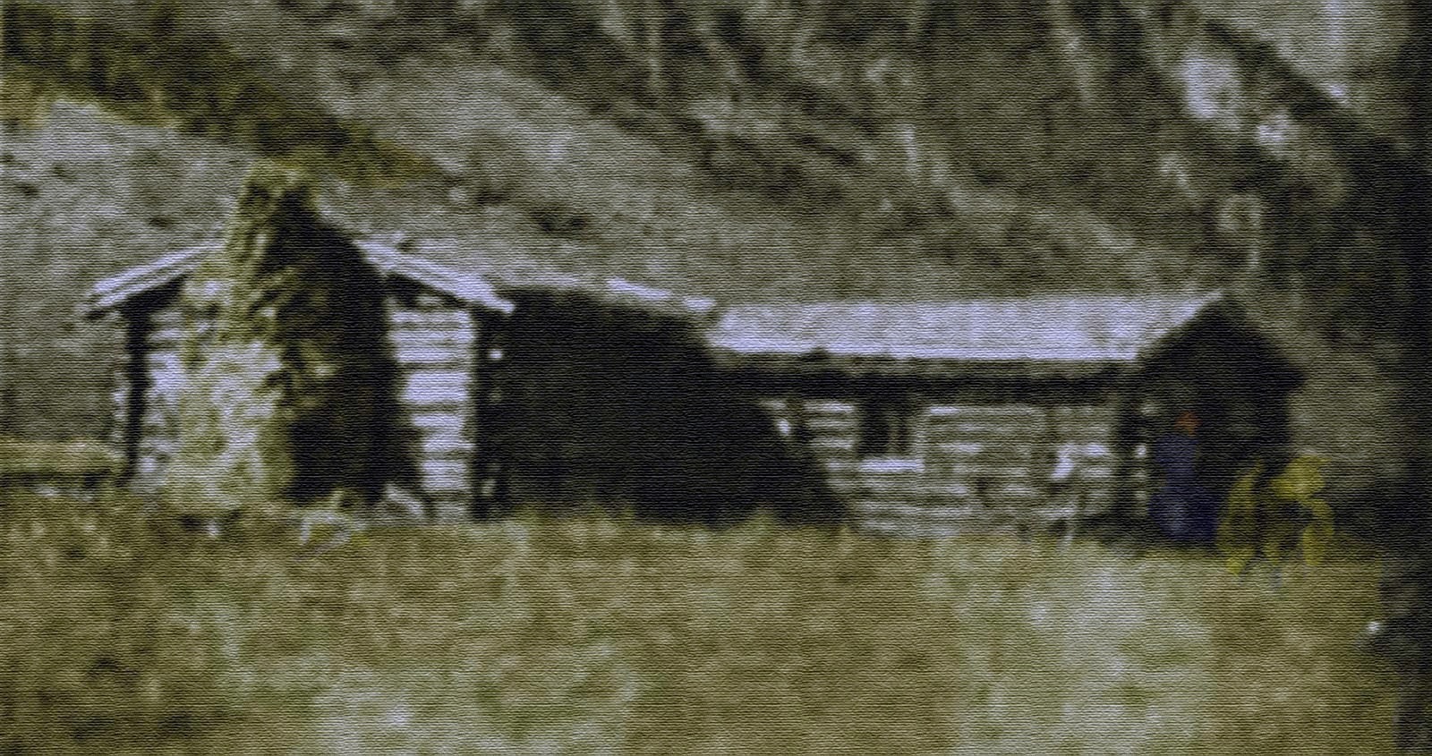
Davis Ranch along the South Fork of the Stinking Water.
Artwork by G.B.Dobson based on 1897 photo by Frederick Courteney Selous.
In 1875, orders went forth from Washington that all of the Indians were to return to
their reservation. No longer were they to be permitted to wander free. According to Cody's sister, Helen Cody Wetmore,
in her 1899 The Last of the Great Scouts, The Life Story of Col. William F. Cody
an Arapahoe chief told Buffalo Bill of a wonderous place:
The land to the north and west is the land of plenty.
There the buffalo grows larger, and his coat is darker. There
the bu-yu (antelope) comes in droves, while here there are
but few. There the whole region is covered with the short,
curly grass our ponies like. There grow the wild plums
that are good for my people in summer and winter. There
are the springs of the Great Medicine Man, Tel-ya-ki-ya.
To bathe in them gives new life; to drink them cures every
bodily ill.
In the mountains beyond the river of the blue water
there is gold and silver, the metals that the white man
loves. There lives the eagle, whose feathers the Indian
must have to make his war-bonnet. There, too, the sun
shines always.
It is the Ijis (heaven) of the red man. My heart cries
for it. The hearts of my people are not happy when away
from the Eithity T�gala [the Indian name for the Big Horn Basin].
Mrs. Wetmore relates that in 1882 her brother participated in an exploratory trip on pack mules to the
unexplored interior of Wyoming. Unfortunately, Cody's eyes became inflamed and was thus required to
go blindfolded on the journey. When they reached a certain point, the leader of the
expedition indicated that Cody's blindfolds could be removed. Mrs. Wetmore quotes her
brother:
To my right stretched a towering range of snowcapped mountains, broken here and there into
minarets, obelisks, and spires. Between me and this range of lofty peaks a long irregular line
of stately cottonwoods told me a stream wound its way beneath. The rainbow-tinted carpet under
me was formed of innumerable brilliant-hued wild flowers; it spread about me in every
direction, and sloped gracefully to the stream. Game of every kind played on the turf, and
bright-hued birds flitted over it. It was a scene no mortal can satisfactorily describe.
At such a moment a man, no matter what his creed, sees the hand of the mighty Maker of the
universe majestically displayed in the beauty of nature; he becomes sensibly conscious, too,
of his own littleness. I uttered no word for very awe; I looked upon one of nature's
masterpieces.
Instantly my heart went out to my sorrowful Arapahoe friend of 1875. He had not
exaggerated; he had scarcely done the scene justice. He spoke of it as the Ijis, the
heaven of the red man. I regarded it then, and still regard it, as the Mecca of all
appreciative humanity.
" * * * broken here and there into
minarets, obelisks, and spires * * *", scene on the Upper Shoshone River.
Thus it was, according to Mrs. Wetmore, that Cody determined to return. Mrs. Witmore's story must
must be taken with a grain of salt. The influence of dime novels pervades much of the
writings of Buffalo Bill and his sister. Louisa Cody in her 1919 biography of her husband Memories of Buffalo Bill
sheds little light on why Col. Cody moved to the Big Horn Basin.
Buffalo Bill's T E Ranch, near Meeteetse, undated, photo by F. J. Hiscock
[Note: The Writer has received several notes from residents of Cody that the caption relating to "near Meeteese" is in error;
The complaint is that while the ranch is physically closer to Cody and today it is reachable conveniently only from
Cody. The original caption was based on the Ranch's location when the photo was taken when there were no convenient roads to the area and
mail into the foothills of the Absarokas came over a trail from Meeteetse to "Fourbear" and Ishawooa (Shoshoni for wolf "droppings.")
Cody would at the time not been a good
point of reference.
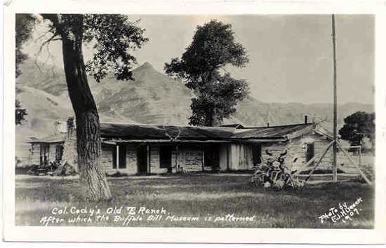
Nevertheless, in 1894 before Cody had been formed or even named,
Col. Cody permanently moved to the T E Ranch which he had purchased from Carter and constructed his house near where
Captain Belknap's cattle company had maintained a cow camp.]
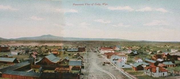
Cody, Wyoming, approx. 1910
Cody was platted in 1895 by Beck and Alger, with whom
William F. Cody joined after learning of the proposed development from his
son-in-law, Horton Boal (1865-1902), one of the surveyors for the project. The first building was constructed
in 1896. Thus, Cody celebrates its founding as 1896.But even after the "city" was incorporated in 1901 is was not much.
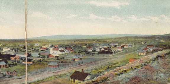
James W. Hook in "SEVEN MONTHS IN CODY, WYOMING, 1905-1906" 26 Annals of Wyoming, January 1954, p. 3,
described his first impression when he arrived in 1905:
My first impression of Cody on that early September morning
was not of the drab little town itself, but of what I saw and heard
beyond its borders. The town, of course, was interesting enough,
but in the midst of the larger scene it seemed markedly artificial
with its low wooden buildings, many just shacks, its unpaved
streets, weed-infested irrigation ditches and rickety board walks
where sidewalks existed at all, the whole in a setting of treeless
and rock strewn terrain.
Originally, Cody proposed to locate the town at the Springs, but eventually
the town was located about a mile downstream. There was much haggling over whether the town was to be
called Shoshone, Cody City, or Cody. Shoshone was rejected by the Post Office because of
possible confusion with Shoshoni.
By 1901 the Cody Club, an ancestor of the
Chamber of Commerce, was formed.
Boal was the husband of Cody's oldest daughter Arta. Both Beck and Alger had
run for governor on the Democrat slate and had been defeated. Beck was first
bypassed by President Cleveland for territorial governor, when Cleveland appointed
Thomas Moonlight of Kansas. Beck was then defeated in a race for Congress in 1890 and
again lost a race for governor in 1902. Alger, a banker, served as mayor of Sheridan in 1889, but
was defeated in the race for governor in 1898.
Next Page: Cody continued, Early Cody.
|